 by
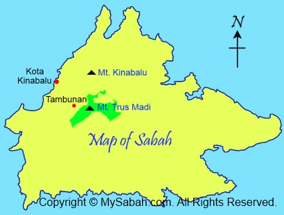
by (Note: The trail & accommodation have improved a lot after 2014. Please check out my latest Guide on Climbing Mt. Trusmadi.) God really blesses Sabah, because the top 3 highest mountains of Malaysia are in Sabah. I guess the highest mountain, Mount Kinabalu (height: 4,095M), is no stranger to Sabahans. Many even climb it more than once. But most of us haven’t tried to climb the second highest mountain of Malaysia, Mt. Trus Madi (height: 2,642 Meters or 8,668 feet).
>> Click Here to see more photos of Mt. Trus Madi
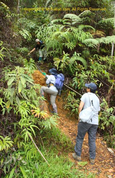
Lack of promotion is responsible for lack of visitors to Mt. Trus Madi. Another reason is – the climb is so challenging that someone even call Trus Madi “Terus Mati” (mean “Die Straight” in Malay language). Of course it is only a joke, as accident in climbing Mt. Trus Madi is rare. Though 1,453 Meters lower than Mt. Kinabalu, Mt. Trus Madi is harder to conquer. Some say if the trail to Mt. Kinabalu is a highway, Trus Madi trail is a countryside road then. The climbers have to be reasonably fit. Personally I would not recommend people younger than 15 years or older than 60 years to challenge the real “mountain power” of Mt. Trus Madi.
>> Click Here to see more photos of Mt. Trus Madi

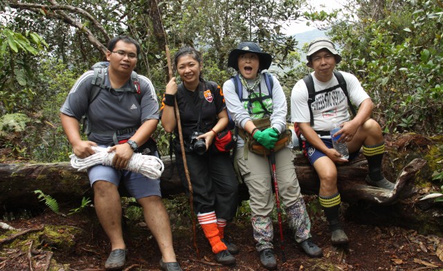
Earlier this month, I climbed Mt. Trus Madi with 5 ladies and all of us made it to the top, despite the poor weather. Thanks to the Internet, I can bring my photos and experience to your screen. I strongly recommend Mt. Trus Madi to hardcore hikers and nature lovers. You will be dearly impressed by the pristine conditions of Mt. Trus Madi. At least you will be proud of yourself for conquering this mountain.
About Mt. Trus Madi
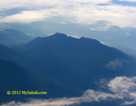
The name “Trus Madi” is originated from the Dusun words “pinotorusan Madi”. Pinotorusan means Hunting Ground and Madi is the name of a hunter who was used to hunt in Trus Madi. Due to higher altitude, the temperature on the mountain is about 10 to 25 degree Celsius. The flora of Trus Madi is very rich and unique. About 600 species in 160 families of plants were recorded in forest here.
>> Click Here to see more photos of Mt. Trus Madi
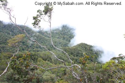
Mt. Trus Madi encompasses 5 different types of vegetations, i.e. lowland mixed dipterocarp (427-600M), hill mixed dipterocarp forest (600M – 1,500M), lower montane forest (1,500M -2,000M), upper montane forest (2,000M – 2,500M), and summit scrub (2,500M – 2,640M). You will pass through all these vegetation zones during the climb. The hybrid vegetation of montane forest and summit scrub is so unique that it is not even found on Mt. Kinabalu!
The Itinerary
The climb will take 3 days 2 nights. The climb starts in Tambunan (90 KM away from Kota Kinabalu). You can choose not to overnight in Tambunan town, but you need to move early at 6am from Kota Kinabalu, to drive 1.5 hours to meet the tour operator in Tambunan town before 8am. Below is the standard itinerary:
| DAY 1 | |
| 5:00pm | Depart to Tambunan (from Kota Kinabalu city) |
| 6:30pm | Arrive Tambunan town & overnight there |
| DAY 2 | |
| 7:00am | Breakfast |
| 8:00am | Briefing and preparation |
| 8:30am | Depart to Mt. Trus Madi’s Starting Point by 4-Wheel |
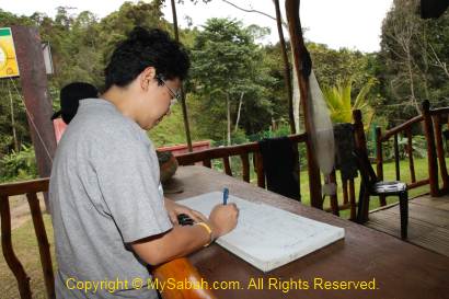
| 9:30am | Arrive Forestry Check Point Gate & Register |
| 9:45am | Proceed to Starting Point |
| 10:30am | Starting climbing Mt. Trus Madi (3.4 KM). Lunch enroute |
| 5:00pm | Arrive Cabin |
| 7:00pm | Dinner |
| 9:00pm | Overnight at cabin |
| DAY 3 | |
| 2:00am | Wake up call |
| 2:30am | Breakfast |
| 3:00am | Ascend to summit (1.5KM) |
| 5.30am | Reach summit to view sunrise |
| 7:00am | Descend to cabin |
| 9:00am | Arrive Cabin. Tea break & Packing |
| 10:00am | Descend to Starting Point |
| 4:00pm | Arrive Starting Point and proceed to Kota Kinabalu |
| 6:30pm | Arrive Kota Kinabalu |
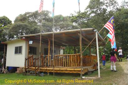
For the first day, I stayed in a resort in Tambunan. Its service sucks so bad that I don’t want to mention its name here, coz I don’t want to promote this stupid resort.
Day 2
The next day I wake up around 7am to get prepared for the climb. After I had my breakfast at 8am, the guide and porters met us at the resort. After a short briefing and loading my bags to their 4-wheel, we headed to the starting point of the climb at 8:30am.
Going to Starting Point
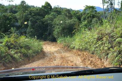
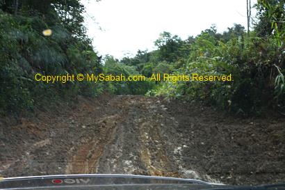
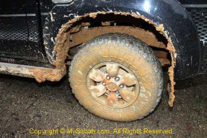
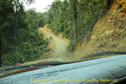
The road, mainly gravel and muddy path, to the starting point is about 30 KM away from Tambunan. The mud is the soft, sticky, smooth and slippery yellow clay soil, so the road is only accessible by four-wheel drive. The engine of our 4-wheel roared and tried really hard to catch very bit of the almost inexistent fiction.
>> Click Here to see more photos of Mt. Trus Madi
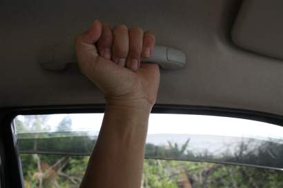
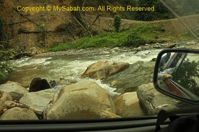
On the muddy road, the car was like gliding and skiing on the mud, and swing violently in zig-zag like a wild bull. The steep slope with loose pebbles also posed a challenge. Our highly-skilled 4-wheel driver shifted gear quickly back and forth, to fight for every inch forward. To be frank, I was freak out. I held the handler so hard that as if I was giving birth a baby. May be I can call it an adventure.
>> Click Here to see more photos of Mt. Trus Madi
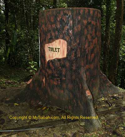
After 35 minutes, we reached the gate of the Forestry Check Point, where everyone was required to register. We also used the “tree” toilet there. It is a man-made structure, not a real tree.
>> Click Here to see more photos of Mt. Trus Madi
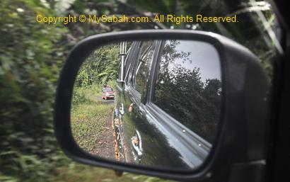
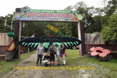
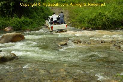
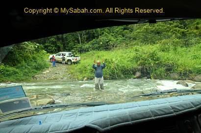
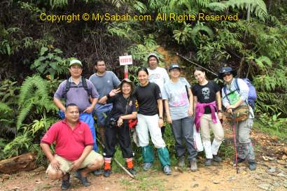
After taking a group photo at the gate, we continued our 4-wheel journey to the starting point. After the checkpoint, the ride was not that bumpy. But then I was terrified when the driver attempted to cross the river. I started to have horrifying imagination of our car being swept away by the river. My worry was needless and we crossed two rivers without any problem. Only now I truly realize the power of 4-wheel drive. Since 4-wheel is meant for adventurers, I wonder why those old aunties and uncles drive 4-wheel in city only and keep it so clean?!!
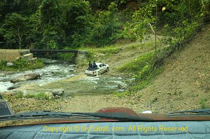
>> Click Here to see more photos of Mt. Trus Madi
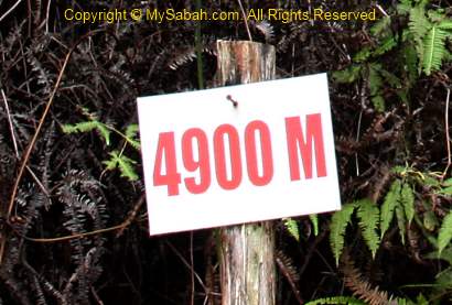
After 40 minutes, we arrived the starting point of the climb. There is nothing there except a “4900 M” signage, which means we are 4.9KM (4,900 Meters) away from the summit of Mt. Trus Madi. 4.9 KM sounds like a short distance on flat ground, but it is not the case for the rugged terrain. They say this is a new starting point, which cut down the distance by 2 hours (about 3 to 4 KM). Many say we would see many blood-sucking leeches at the Starting Point, but luckily we didn’t see any.
>> Click Here to see more photos of Mt. Trus Madi
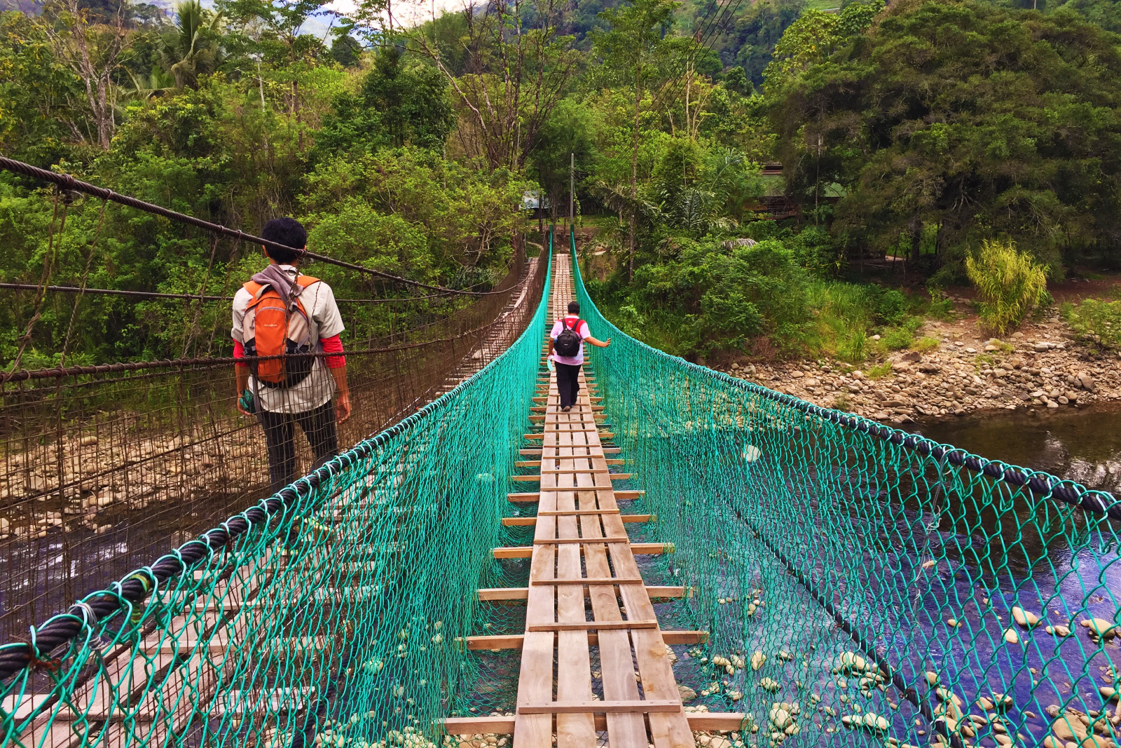
Photos taken in Tambunan, Sabah, Malaysia Borneo
Hi! Loved reading your Trus Madi adventure. (Read them backwards, though.) Beautiful pics, too. I’m one of those aunties with clean 4-wheel vehicles in the city! It’s like this: if we want to go adventuring, we already have the wheels… hehe. BTW the gradient in the pic above looks like 75 degrees! And in at least one pic I saw people walking in a gully!
Thanks for sharing… wishing you lots of fantastic adventures!
Hi
I like your article of Mt Trusmadi. A group of us are planning a challenge of climbing Mt K and Mt Trusmadi within a week. Wonder if you can recommend us as to what tour operater did you go with and most importantly, which resort in Tambuhan should we avoid.
Regards,
Alex
Thanks Alex, you can contact Tropical Mountain Holidays (Tel: +6 087 773992, mobile number: +6 013 549 2730, email: tmhtimbou@yahoo.com, website: http://www.tropicalmountainholidaysmalaysia.com) directly for the tour + accommodation package.
Haha Tina, then you should try climbing Trus Madi, so you can put your 4WD into full use. The climb is not as bad as it looks, but a bit of physical training really helps.
Hi,
Five of us have just completed the top 3 Gunung in Malaysia in 1 climbs.
It was a good adventures, trekking and memorable experiences for all of us.
Our 1st attempt:
G2..4.9km Ascending to the peak of Mt. Trusmadi on the 9th – 10th September 2010.
2nd attempt:
G3..14km Ascending to the peak of Mt. Tambuyukon on the 12th – 14th September 2010.
3rd attempt:
G1..8.5km Ascending to the peak of Mt. Kinabalu on the 15th – 16th September 2010.
For those planning to climb these mountains, you may find recent photographs taken by our group. Just tag me your facebooks and you may find some wonderful photo there..he..he.
XPDC Merdeka 2010 team.
jacky.chuact@gmail.com
Jacky> OMG, that sounds so crazy! I always want to climb 3 mountains but never dare to do it in one go. congratulations to your great achievement!
Btw, how did u get that monkey? lol
TQVM from your great sharing.
I can figure out now hehe..
Any accommodation at starting point/entry point?
Allow own 4wheel drive to starting point? How bad the river? I’m worry that haha
tank, u r welcome. there is no accommodation at the starting point. if i am not mistaken, u can camp there. but there is no facility such as toilet around.
u can enter with your own 4WD. but u need to register with Sabah Forestry Dept and pay the permit fee.
about crossing the rivers, whether it is easy will depend on your driving skill. our driver can cross it quite easily. but it is more challenging when the river is flooded in rainy day.
Wow, I wonder about the conditions of the trucks after going through such abuse regularly. That river such looked scary!
What is the black horizontal bridge-like structure in the 5th picture (from below)?
My family has a 4WD too, though it’s a Land Rover from 1950’s ha-ha. We used to use that for our trips to Kuala Penyu before the road was tarred.
Emily> the trucks r still ok, as they r built for such abuse mah.the bridge-like structure is a small bridge.
i also wish i own a 4wd, can go anywhere i like.
if you want to climb, book tmhtimbou@yahoo.com or visit their website http://www.tropicalmountainholidaysmalaysia.com
Hi, any information about climbing mt. trus madi recently? please email me @rhozsy@gmail.com for any booking agency I can contact. Thanks!
Hi Rose, you may check out my climbing guide at: https://www.mysabah.com/wordpress/guide-to-climbing-mt-trusmadi/