Tag Archives: environment

liana

The 10 Most Interesting Trees of Borneo

Most tourists have an impression that Borneo is a tropical island full of coconut trees. As a matter of fact, in only 10 sq. KM of Borneo rainforest, there are more flora than that of North America and Europe combined. Without rich diversity of tree species as a food source and habitat, our most charismatic wildlife such as orangutan would not survive.

Our trees are not boring. Let’s look at 10 of them. You would be surprised that most of them are closely related to your life.

1. Belian, the Ironman tree

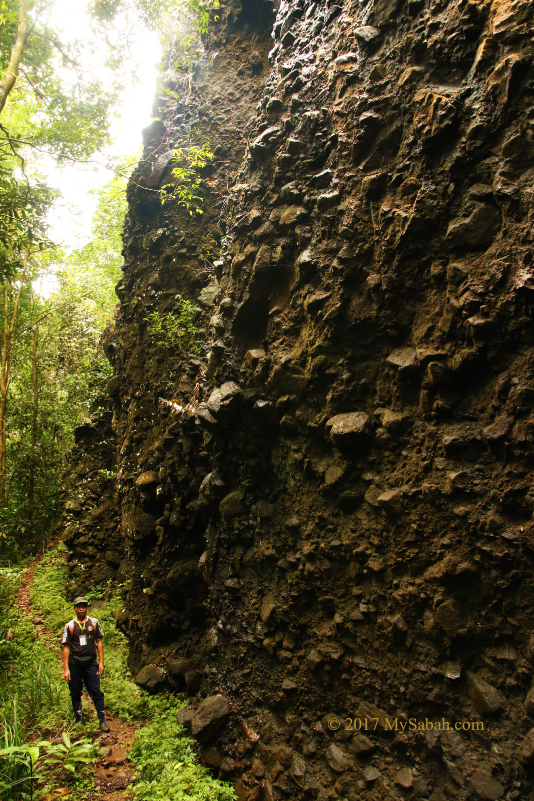
Locally known as Belian, Borneo’s ironwood (Species: Eusideroxylon zwageri, Eusideroxylon means sinking wood) is the heaviest, hardest and most valuable timber of Borneo. Belian can live over 1,000 years and it grows extremely slow (mean radial rate of 0.058cm per year), reaching only a diameter of 30cm even after 120 years. That’s why it is so hard and dense that it doesn’t float on water and termites can’t bite through.


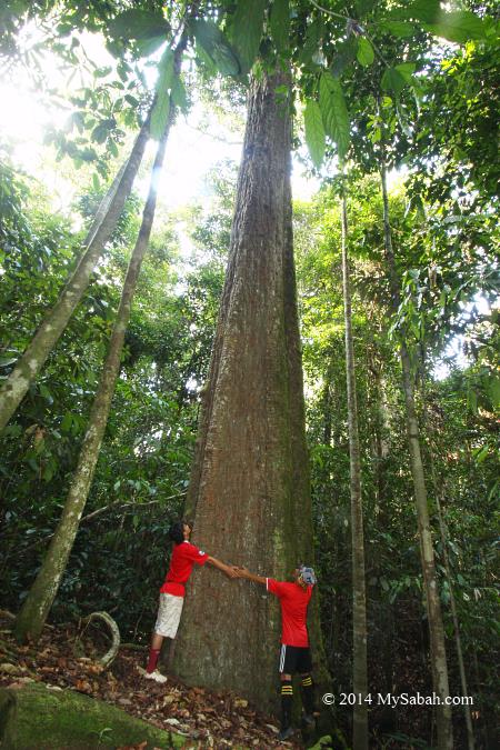
Pic: hundreds year old Belian in Imbak Canyon


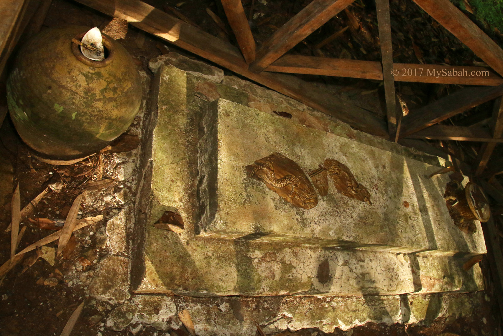
Pic: 200-year-old Belian coffin in Danum Valley

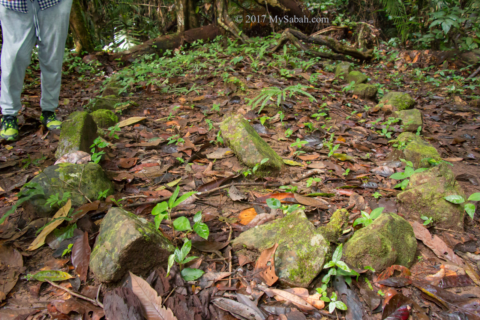
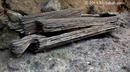
However, this hardwood can’t fight chainsaw and millions of them are fallen by greedy loggers who see it as a standing gold bar. Now only a small number of Belian trees live in most remote forest of Borneo. Belian is so strong and resistant to decay that it can last 200 years in worst condition, so it’s the best wood for jetty, dock and piling. In history, China emperor used it as the pillars of Forbidden City, Murut (Borneo headhunter) used it to make blowpipe, Dusun ancestors used it to create coffin.


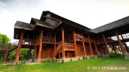
Pic: Murut Cultural Center supported by Belian wood pillars

2. Tongkat Ali, the Viagra tree

Ask any Malaysian what is Tongkat Ali (Eurycoma longifoliam) and note the sheepish smile on their faces. Tongkat Ali is viewed as Malaysian Ginseng and has been used as a traditional aphrodisiac. You can buy Tongkat Ali readily for cheap price at local markets and even tourist souvenir shops (it’s a hot selling item, from what I heard).


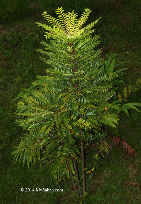
Pic: Tongkat Ali tree

Literally Tongkat Ali means “Ali’s Walking Stick.” It can grow up to 5m tall and 20cm in diameter and prefers well-drained forest slopes under partial shade. It looks like a small tree but what under its stem is long and fat root. To harvest its root, you need to tie its stem with a rope then have two men to pull it out of the soil. Tongkat Ali has two types, one with white root, which is more common and tastes really bitten, another is black color, which is better but rarer.


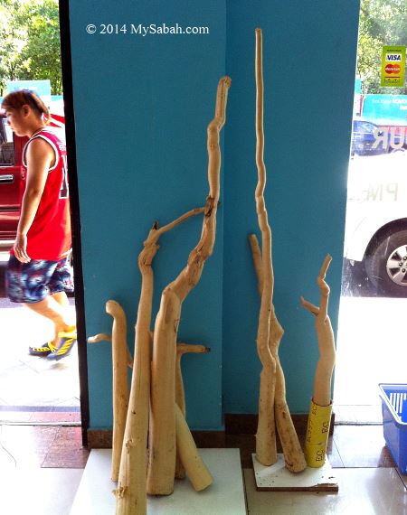
Pic: roots of Tongkat Ali

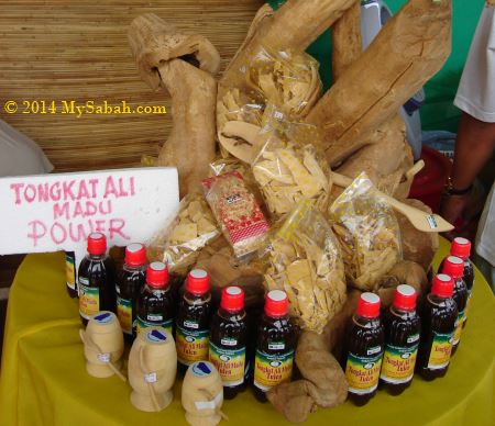
The root of Tongkat Ali has sexually-enhancing and testosterone-raising effect (its leaves can relieve stomach pain). The decoction of the pounded and boiled root is a popular drink to improve the potency of men hence a happy sex life. Now you even can find Tongkat Ali Coffee on the market (a few friends told me it really makes them “hard”). Hey, why bother about the expensive blue pill?

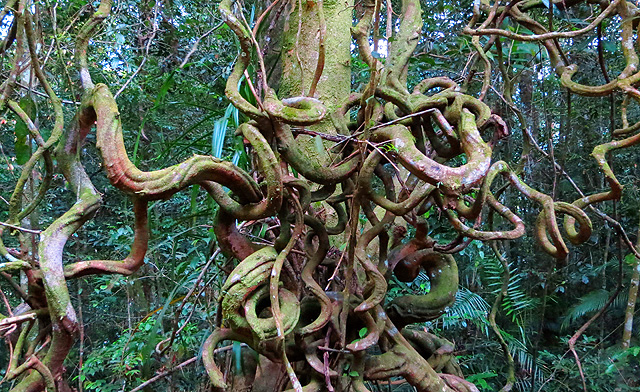
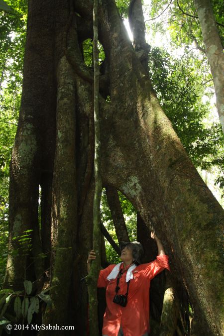
3. Strangling Fig, the tree Killer

Ever heard of a tree strangles another tree to death? This is not a fiction. The tragedy starts from a seed of strangling fig (Ficus spp) being carried in the poo of fruit-eating animals such as bird and squirrel to the treetop.


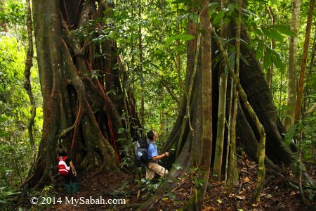
Pic: huge strangling fig trees in Maliau Basin

The seed germinates on the big tree and sucks nutrients out of it. Over time, this parasitic tree slowly spreads its branches from the crown of the host tree to the ground, the roots joined when meet, forming a basketwork of interlacing roots around the trunk. Strangling fig tree will grow faster once its roots reach the soil for more nutrients, the roots thicken and constrict the flow of nutrients of its host, eventually the host tree dies.


Pic: hollow left by the decayed host tree

The murder takes many years to happen. At the end, strangling fig wins, flowers and its fruits will attract another seed-carrier which poo on the next victim. Thing gets more interesting after the dead tree decomposes, as it will leave a hollow inside the new tree. Strangling fig sounds evil, but its fruit is an important food source for wildlife. Btw, be careful when a bird poo on your head lol.

4. Menggaris, the Honey Bee tree

In Borneo jungle, even the most casual hiker would not miss the towering Menggaris tree (Koompasia excelsa), a member of the bean family. Menggaris is a beautiful tall and straight tree which can easily exceed 60m in height and grows up to 88m, one of the tallest tree species in Borneo rainforest.

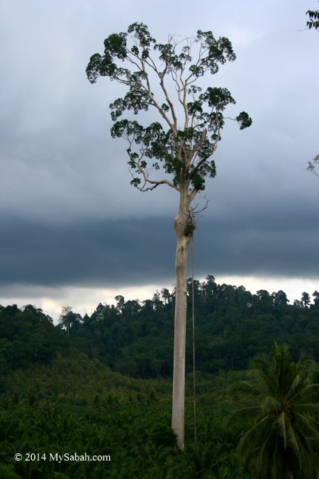
Its cylindrical bole with grey and smooth bark poses a big challenge to excellent climbers such as sunbear and orangutan. Therefore, Menggaris naturally becomes the favorite nesting tree of wild honey bees (Apis dorsata), to keep their honey out of reach to sunbear the honey lover. It is common to see over 10 bee hives under the branches of same Menggaris tree.


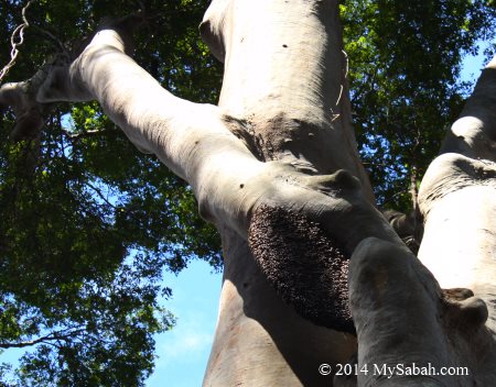
Pic: bee nest on Menggaris tree

Luckily, because of its hollow trunk, Menggaris is not a good timber, so you can see them remain standing on a deforested land. Villagers will build climbing aid on Menggaris tree to harvest its honey. Got honey got money. Menggaris is also considered as a sacred tree in Dayak folklore of Sarawak.


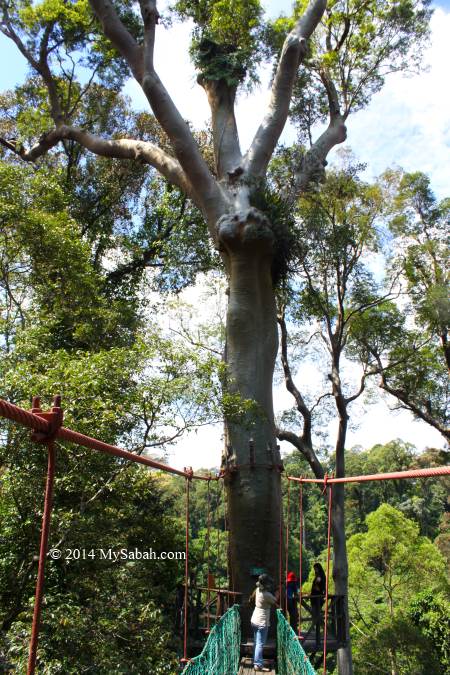
Pic: canopy walk allows you to see Menggaris up-close

5. Gaharu, the Perfume tree

Gaharu (Aquilareia malaccensis) is also known as agarwood, incense wood and aloes wood. This intensely fragrant resinous wood is widely used in religions (some even calls it the “Wood of the Gods”), probably it resembles the smell of heaven so its price is sky high too, at least US$1,000 per Kg. There have been local and foreign thieves who trespass our protected forest to collect agarwood illegally.


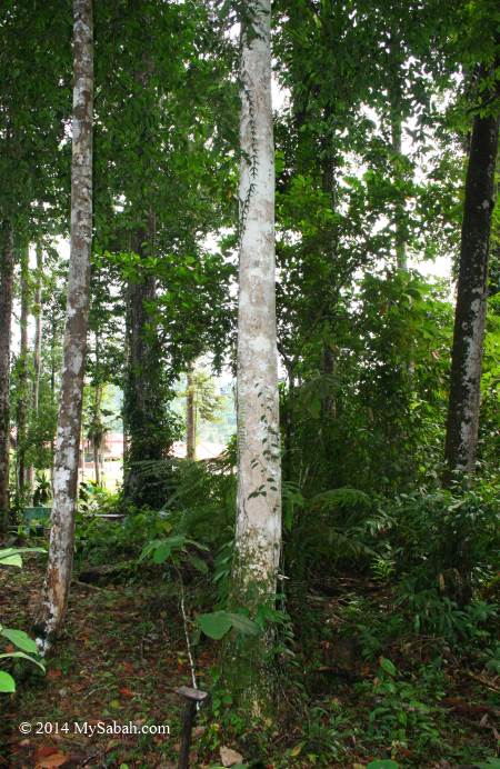
Pic: Gaharu tree in Tawau Hills Park


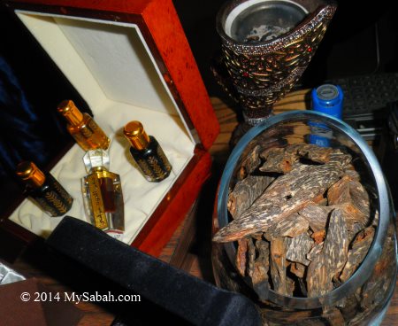
Pic: agarwood products for sale

Normally the wood of Gaharu tree is white and has no odor. But if the tree is infected by fungus, it’ll produce dark aromatic resin to protect itself. This agarwood is not only highly prized as an incense, it is an important ingredient for perfume industry. Some farmers include gaharu as one of the crops in their integrated farming.


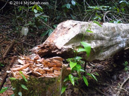
Pic: Gaharu tree cut by thief

6. Mangrove, the Summer Xmas Tree

Growing in smelly and muddy swamp land, how can mangrove trees (Rhizophora spp) be interesting? In old days, mangrove forest was considered a wasteland full of mosquitoes, and people weren’t hesitant to clear it. Now we know that mangrove ecosystem serves an important role in flood mitigation, prevention of coastal erosion and as a feeding ground for migratory birds.


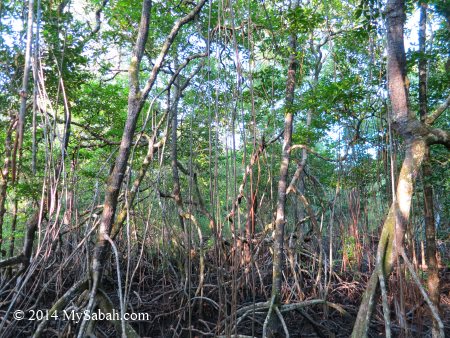
Pic: note the breathing roots of mangrove trees

Sabah occupies 59% of total mangrove area in Malaysia. Mangrove is the nursery of seafood and that explains why Sabah is abundant in seafood. Mangrove is also the habitat of Proboscis Monkey, our endemic Borneo monkey which attracts a lot of tourist$. At night, hundreds of firefly congregate and twinkle on mangrove, turning the tree into a Summer Xmas tree. Nowadays, the well-being of our seafood and tourism industries depend heavily on healthy mangrove.


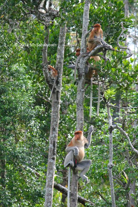
Pic: proboscis monkey family on mangrove tree


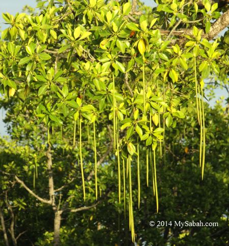
Pic: vivipary, the spear-shaped seed of mangrove

Living in tidal zone, mangrove tree develops many interesting features to adapt to this harsh environment. It uses stilt roots to breathe and hold itself firm in the mud. Its torpedo-shaped seed (vivipary) may look peculiar, but it helps the seedling to anchor in the soft substrate when detached from mother tree.


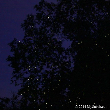
Pic: firefly Summer Xmas Tree in Klias Wetland

I would say mangrove tree is the most useful tree because it benefits everyone of us.


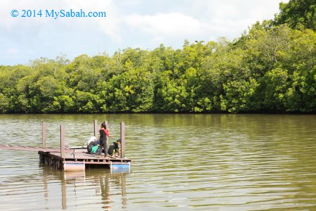
Pic: river of mangrove is always a good spot for fishing (watch out for crocodile though)

7. Oil Palm, the Money tree

Well, oil palm (Elaeis guineensis) is not so “Borneo” but this native species of West Africa has blanketed nearly 20% of Sabah, the largest palm oil producing state in Malaysia. Now oil palm is a cash crop so it is quickly turning swaying coconut and banana trees of countryside into ugly palm. Palm oil also enters every corner of our lives, from soap, shampoo, cooking oil, chocolate, margarine, cosmetic, detergent to biofuel.


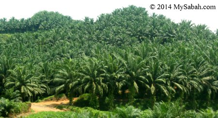
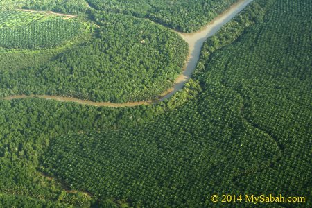
Pic: forest engulfed by oil palm

To be fair, the yield of oil palm per hectare is 10 times more than soybean and sunflower. The crop itself doesn’t cause any problem, only the way how it is planted is earning it a bad name among environmentalists, for example, open burning, deforestation, hill clearing and encroachment to riparian reserve. Anyway, now the government, NGOs and plantation owners are willing to work together to ensure sustainable and environmentally-friendly practices are in place for this crop.


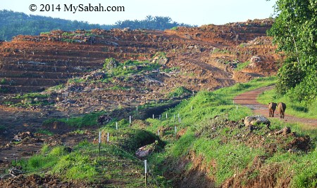
Pic: elephants (right) roaming near a deforested hill

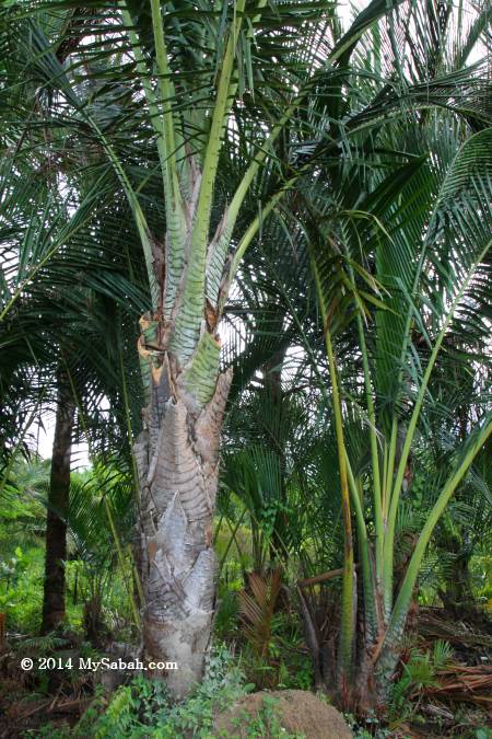
8. Sago Palm, the Edible tree

You may start imagining that you are ordering a piece of wood off a restaurant menu and then biting it like a white ant, or a starving man chewing tree bark. Sago palm (Metroxylon rumphii & Metroxylon sagu) is really edible but you have to process its trunk first.


Pic: the pure carbohydrate from sago palm saved many lives in WW2. Sago Palm is also called The Tree of a Thousand Use. You can use its leaves to make handicraft and roof, and its trunk to build houses, etc.

Sago is one of the staple food for people living in south-west of Sabah (Kuala Penyu and Beaufort) and they even celebrate Sago Festival annually. To extract the starch of sago palm, they pound the soft kernel of the trunk into chips, wash the pulverized pith with water, collect the starch and dry it. Sago can be made into different delicious food such as cake and pudding, and the traditional way to enjoy it is to make Ambuyat, a translucent and sticky sago paste, which is served with fish and sour soup.


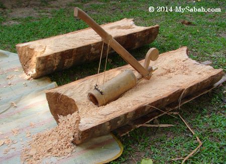
Pic: the traditional tool of sago processing. Now it’s replaced by machine.


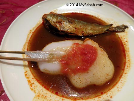
Pic: Ambuyat.. yummy..

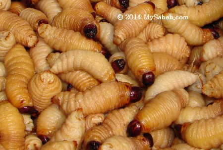
During sago processing, the farmers also pick up some wiggling fat larvae of beetle (Butod) which is well-fed in kernel. Some locals consider this juicy butod a delicacy and love to eat it alive. Are you keen to try?

9. Pelawan, a Naked tree

There is a Chinese proverb says, “Man needs face as much as tree needs bark”, so I was surprised to see Pelawan tree (Tristaniopsis spp), which is a member of the Myrtaceae and quite common in lower montane forest of Sabah highland.

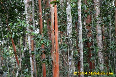
About 20 species of Pelawan are found in Borneo and these bizarre trees are characterized by flaky orange bark. The tree is so beautiful that there is a story which says other trees were so jealous of its fashionable peeling bark that they beat it with branches.


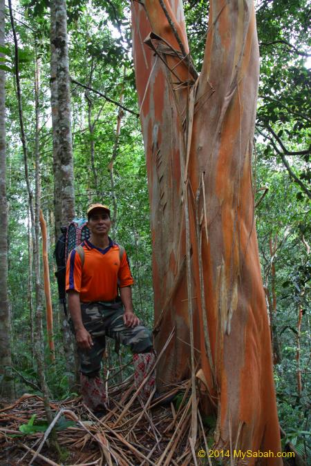
Pic: Tristaniopsis tree in Long Pasia

This phenomenon is just a growing process of Pelawan, the old bark peels off when the fresh bark emerges.

10. Kerosene tree with Petroleum Nut

If your tour guide brings you to Botanical Garden of Kinabalu Park, he will definitely show you a cool trick by igniting the fruit of Kerosene tree (Pittosporum resiniferum) like a candle. Yes, the fruit of Kerosene tree is inflammable and can be used in producing biofuel. This tree is less than 10m tall and grows between 400m and 2,300m above sea level. In old days, locals use the oil of this fruit for lamp.


Pic: fruits of Kerosene tree (Source: Dick Culbert)

Some birds eat this fruit, but it is unclear that if it can help the birds to achieve sonic speed in flight. Just kidding.

The list doesn’t end here. Borneo also has the Tallest Tropical Tree in the World. Please share with me in comment section below, if you know other interesting trees of Borneo.

Photos taken Sabah, Malaysia Borneo

Serinsim, a different face of Kinabalu Park

A family is having a hard time to plan a holiday trip at a destination that makes everyone happy.

Grandfather: “I want to learn some local history and legend.”
Mother: “How about a BBQ feast?”
Father: “Let’s climb a mountain.”
Son: “Camping and jungle trekking will be fun!”
Daughter: “I love swimming in river.”

Location of Serinsim (Sorinsim) and Kinabalu Park

Finally they decide to visit Serinsim (or Sorinsim) in Kota Marudu, which has all these. There is no second place in Sabah where we can find river, waterfall, forest, cave, mountain and historical site in one park.

Signage to different attractions inside Serinsim. It’s ok if you can’t read Malay. I’ll tell you what they are later.

Serinsim is a substation in northern part of Kinabalu Park, the first UNESCO World Heritage Site of Malaysia. Lies between the Serinsim and Kanarom rivers, the river of Serinsim is straight from the undisturbed rainforest and mountain, so its water is crystal clear and almost as good as Spritzer.

Kanarom River in Serinsim (Sorinsim)

You may be familiar with the mountainous zone in Kinabalu Park HQ in Kundasang highland. Serinsim is at opposite side of HQ, which is dominated by lowland rainforest, shows different face of Kinabalu Park. Most locals only come here to enjoy the cooling river, without knowing that Serinsim has the following special attractions:

1. Mount Nombuyukong (Gunung Nombuyukong)

With a height of 1,603.57 Meters, Mt. Nombuyukong is 976 Metres lower than its sister peak, Mt. Tambuyukon, the third highest mountain of Malaysia. Mount Nombuyukong can be conquered within a day.

Mount Nombuyukong in Serinsim

>> Read about the challenging climb to Mt. Nombuyukong…

2. Bat Cave (Gua Kelawar)

Gua Kelawar is a small cave about 200 Meters long, and it is for the adventurous you who like the idea of exploring the unknown. *Hint:* many creeping critters in the darkness. I saw rare mushroom and endemic begonia outside the cave.

The rocky wall of Bat Cave (Gua Kelawar) in Serinsim

>> Read my scary story inside Bat Cave…

3. Misumpak Waterfall

Serinsim is more than a park for swimming and picnic only. Do a jungle trekking to visit the 12-Meter Misumpak Waterfall. Soaking in its cooling ponds will be one of the best nature experience, I promise. You would see hornbill, civet, red leaf monkey, orangutan and other wildlife on the way.

Misumpak Waterfall and its pond

>> Read more about Misumpak Waterfall…

4. Gambaliu, the Tallest Man in the World

According to the local legend, a giant named Gambaliu lived here about two to three thousand years ago. With a height of 24 feet, Gambaliu is taller than giraffe. He was a gentle and helpful giant. However, what his people did after he died was sort of… heartless.

Tomb of Gambaliu, the tallest man

>> See the Tomb of Gambaliu…

5. Sigunting Graveyard

Sick of those cliche movies about superheroes saving the mankind? Let’s hear the story of real Sabah hero, Si-Gunting, who fought British imperialism for 7 years.

Graveyard of Sigunting, a Sabahan hero

>> Read more about Sigunting…

6. Deer Farm

About 120 Meters from the hostel (Asrama Kanarom) is a 0.5-Acre of fenced and forested Deer Farm. The best time to visit is the feeding time at 2pm, the time about 10 Sambar deers show up for jackfruit, tapioca leaves, banana, and fruits given by the Park.

Deer Farm of Serinsim. Visitors can walk up to the tower for better view.

Below is the trail and layout map of Serinsim. Please note that for most jungle trekking activities, you are required to hire a guide from the Park, which can be arranged easily one day in advance.

Trail map to different attractions in Serinsim. Translation: Pejabat = Office, Galeri = Gallery, Pondok = Gazebo, Pelawat = Visitor, Tapak Perkhemahan = Camping Ground, Tandas Awam = Public Toilet, Dapur = Kitchen, Sungai = River, Sg. = River, Anak Sungai = Small River, Jalan Raya = Road, Jambatan Kerata = Bridge for Car, Air Terjun = Waterfall, Makam = Grave, Puncak = Peak, Kem = Camp, Ke = To

Accommodation

Three chalets and one hostel are available to accommodate three families and 24 people respectively in the Park. Below is a quick comparison of the price. The rate is as of July 2017, and GST tax is included.

Accommodation TypeRate per Night
CampingAdult: MYR5.30 (≈USD$1.32)
Below 12: MYR2.15 (≈USD$0.53)
Hostel (Asrama Kanarom)Adult: MYR42.40 (≈USD$10.60)
Below 18: MYR31.80 (≈USD$7.95)
Chalet1 Chalet: MYR318.00 (≈USD$79.50)
1 Room: MYR106 (≈USD$26.50)

Notes: Check-out time is 11:00am. Non-halal food such as pork is forbidden in the accommodation. The accommodation is not well-maintained. Before you unpack your luggage, make sure everything in your room is functioning (e.g. water supply, light, air-cond). Just in case anything is broken, you can change to other room quickly.

Asrama Kanarom Hostel

Asrama Kanarom Hostel is a dormitory-style one storey building which has four bedrooms, common toilet + bathroom and kitchen. Each room has 6 bunk beds, so this hostel can host about 24 people.

Asrama Kanarom Hostel in Serinsim
Interior of Asrama Kanarom Hostel in Serinsim

The fee for each bunk bed in hostel is MYR42.40 for adult and MYR31.80 for kid (below 18 years old). The room has air-conditioner, and pillow and blanket are provided. It’s an economic choice for budget travelers and student group who don’t mind to share room.

Bunk beds in Asrama Kanarom Hostel

The kitchen has gas stove, cooking and dining utensils for use by the guests. Electricity and water supply are available all time.

Kitchen of Asrama Kanarom Hostel

However, there is no private bathroom. Guests can share the common unisex toilet and bathroom. Sorry, no water heater for a hot shower, but you can boil hot water in kitchen like what I did.

Toilet cum shower room, cooking area, utensils and refrigerator in Asrama Kanarom Hostel

One nice thing about this hostel is that it’s located next to the starting point of trail to all nature attractions.

Chalets

There are three chalets in the Park. You can book the whole chalet for MYR318 per night, or rent a room for MYR106. Each chalet has three rooms (two of them are single bed). Each chalet is limited for 6 people. For additional guests, you need to pay extra MYR30 per person.

There are 3 chalets in Serinsim Substation
Chalets of Serinsim

Each room has an attached bathroom cum toilet. Heater for hot shower is not available. Soap and towel are provided for the guest. Every room has air-conditioning.

Chalet of Serinsim (or Sorinsim). At the left is Mt. Nombuyukong
Bedroom, living room and kitchen of Serinsim Chalet

Camping

Camping ground is also available to those who desire a more nature experience. For adult, the camping fee per night is MYR5.30 and MYR2.15 for child below 12. You can rent a camping tent for MYR30/day at Sabah Parks office, or bring your own.

Camping ground of Serinsim
Gazebo and benches at camping site

The campsite is just next to the river. There are gazebos, benches, public toilet and kitchen nearby that area.

Campers in Serinsim
Kitchen near camping ground

There is no lighting at night, so you better bring your camping light and torchlight.

Barbecue party at the hostel

There is no TV, karaoke and night life in the park, so you will get bored in the evening. Do plan some fun activities for the night, for example, board games, BBQ party, strip poker, watch movies on laptop.

Playing Uno in the hostel (Asrama Kanarom)

By the way, Kota Marudu is famous for its maize. You can buy some along the way and grill it, it’s delicious.

Layout Map of Serinsim Substation

Don’t be impressed by the facilities listed in the map above. Everything in Serinsim is basic, nothing 5-star. For example, the so called soccer field is just a grassland. The restaurant never opens and there is no gallery.

How to get there

Serinsim is about 32 KM from Kota Marudu town and 130 KM away from Kota Kinabalu City (capital of Sabah). This substation is now highly accessible after asphalt highway is complete in 2013. The GPS coordinate is 6.293915, 116.707986 (see Location Map).

Asphalt road to Serinsim in Kota Marudu

In the past you needed a 4-wheel drive to get in. That might be the reason why Serinsim is one of the least explored parks in Sabah. There is no bus goes directly to Serinsim.

You will pass through Marak-Parak Village and Sorinsim Village before you reach Serinsim

You also can go to Serinsim from Poring Hot Springs, the 46-KM road is in good condition.

Signage at the entrance. Translation: Welcome to Kinabalu Park, Serinsim Sub-Station, Kota Marudu

Things to Note

For a better travel experience at Serinsim, please take note of the following:

  1. There is no restaurant in the Park. You can prepare your own food in their kitchen, buy food from villages nearby (The shops are usually roadside residential run by villagers with signage such as Gerai Makan (Food Stall) or Kedai Runcit (Grocery Store)), or drive 30 minutes to Kota Marudu town looking for restaurant.
  2. The mobile line coverage is none or poor in the Park. My Maxis line got 0 bar. Celcom may work. Anyway, let’s prepare to be offline there.
  3. Bring insect repellent. There are mosquitoes in shaded area during dusk and dawn.
  4. There is a grocery shop and cafe outside the park entrance.
  5. Most area in Park has no light. Bring a torchlight if you would move around in the Park at night, especially campers.
Sabah Parks office and car park of Serinsim (Sorinsim)

Entrance Fee

The following is the ticket fee to enter the park. They only accept cash in Ringgit Malaysia (MYR).

ItemFee / Rate
Conservation FeeMalaysian: MYR10.00
Foreigner: MYR50.00
Below 18 years old: MYR5.00 and MYR25.00 respectively
Conservation Fee with effect from 1 Jan 2023
Ticket counter at the entrance of Serinsim (Sorinsim)

Serinsim is managed by Sabah Parks. For more information about Serinsim, you may browse www.sabahparks.org.my or call the head office of Sabah Parks in Kota Kinabalu at +60 88-523500.

Photos taken in Kota Marudu, Sabah, Malaysia Borneo

Serinsim and something about Sabah Rivers

Serinsim (or Sorinsim) is a nature park and substation in northern part of Kinabalu Park (in Kota Marudu, Sabah, Malaysia). Once you enter Serinsim, you can tell its main attraction is the river because many families swim, camp or picnic at the river side.

Camping ground and picnic site of Serinsim

Serinsim lies between the Serinsim and Kinarom rivers. Kanarom River (Sungai Kanarom in local language) is just 10 Meters away from the car park near the park entrance. The river is unpolluted and straight from the fully protected forest, so swimming in this crystal clear and cooling water is like bathing in mineral water.

Cooling and clean water of Kanarom River

During weekends and school holiday, many locals come to frolic in the wide and shallow river, which is kid friendly and not swift. I met a family who drove 130 KM from Kota Kinabalu City (KK) to this place.

No lifeguard around so swim at your own risk

Another reason Serinsim becomes a local family choice is due to the cheap entrance. For example, a local family of parents with 3 children spends less than 10 Ringgit to enjoy the Chlorine-free river. If they go to theme park such as Sunway Lagoon, it can cost them half a thousand Ringgit (but of course the facilities there are far more better and fun).

There are a few gazebos and benches at riverside

The amenities in Serinsim are fairly basic. They have changing rooms cum toilet and gazebos with benches and table near the river. The place is not crowded as it is far away from big city and not a popular tourist destination.

Many families come here to swim during weekends and school holidays

Sabah is blessed with many clean rivers. According to a report of the Department of Environment (DOE) in 2013, about 42% of the 473 rivers in Malaysia were under stress of pollution. In some urban area, the only clean source of water is from the tap.

Cute sisters coming from Kota Kinabalu City

However, this can change, especially downstream that are under constant environmental threats by poorly-managed development and farmland, rampant illegal sand mining, and indiscriminate dumping. More and more rivers turn into milk tea color, or worse, smelly blackish bacteria soup.

Colorful rocks in the river

Ask the elders who have lived in KK for over half a century, they can share their childhood stories of swimming and fishing in crystal clear water of Sembulan River. But look at this river now, it’s so filthy and has become a conveyor belt to transport floating rubbish to our sea.

Most locals come to Serinsim to swim during hot day

While posting the photos of Serinsim here, I also share some random fun facts about our rivers.

River is Good for our Health

Nobody says swimming is bad, unless you swim in dirty water. Indeed, swimming can serve as a medicine, stress reliever, therapy, exercise, immunity boosters, etc. all good for physical and mental health.

The sign of a clean natural river is its emerald color

“Natural waters are full of life, biological energy from plants and different creatures, minerals, enzymes, and many other beneficial substances. Swimming in natural waters has been prized as a therapy for many health problems for centuries.” – moulindebeny.com

Sabah is lucky to have so many clean rivers

The funny thing is – except human and apes, almost every other mammals can swim instinctively, that includes heavy elephant and cats which hate water.

Freshwater Ecology is Magnificent

Even if we close our eyes, our ears would still expose to many conservation messages about Loving our Ocean, to name a few, don’t eat turtle eggs, shark is endangered, plastic kills our marine lives, corals are under threat. Furthermore, we are always awed by the amazing photographs, videos and experience in diving, and determine to protect our marine ecology. Good.

When you visit Serinsim, make sure you get your feet wet

However, compared to ocean, very little is said about river conservation. I would see news about beach cleaning occasionally but not river cleaning so far. To be fair, we have Tagal system (No Fishing) to protect fish stock in Sabah rivers, but it mainly targets at over-fishing.

You know, no water, no life, so no river, no wildlife. Our rivers have been supporting many iconic Borneo wildlife such as Proboscis Monkey and Bornean pygmy elephants. They help our tourism to rake in a lot of cash, so we know it’s imperative to take care of their well-being.

Clean water of Kanarom River

However, we forget the animals live in the rivers. Populations of freshwater species have declined by 76% since 1970, a lot faster than land or marine animals. I was told by my aunt that 50 years ago, the river was so clean that she saw something like sponge corals.

In Sabah rivers, there are 150 native freshwater fish species and 36 of them are endemic (24% of native species), according to the paper titled ?A working checklist of the freshwater fish diversity for habitat management and conservation work in Sabah, Malaysia, North Borneo?.

Kanarom River teeming with fishes

Did you know friendly Irrawaddy Dolphins, monster Largetooth Sawfish and child-eater Tapah Catfish were used to be common in Kinabatangan, the longest river of Sabah? But now what is left are only some interesting stories about them among the villagers.

Some fishes of Borneo rivers are eco treasure too. A giant empurau fish from a Sarawak river was sold for a whopping RM7,900 (nearly USD$2,000). The market price of empurau ranges from RM400 to RM1,000 (USD$100-250) per Kg.

Tyre buoy is available for rent (MYR5.00) in the shop near to park entrance

Though Sabah has no empurau, our Ikan Pelian (Malaysian Mahseer) is doing well too, it is priced for RM80 to RM100 (USD$20-25) per Kg. Both Empurau and Ikan Pelian are belong to same species (but I’m not sure if they are different sub-species).

Therefore, rivers shouldn’t be treated as less important than ocean. Time to do more to save our rare and endemic fishes. River pollution is currently threatening the survival of many rare species. Rivers are more prone to pollution, as they are smaller water bodies than the ocean. One selfish act of a company or village can compromise the health of a river.

Forest & Rivers

If forest is the lung of our planet, then river is the blood capillary of nature. Protecting our forest comes with two significant outcomes, clean air and water, which we can’t live without.

Enjoying the flowing water of river

Humid tropical rainforest can add water to the atmosphere (through transpiration) thereby forming more cloud and bring more rain. The forests in Southeast Asia can influence rain patterns in south-eastern Europe and China. Lose of moisture due to deforestation can lead to drought.

Furthermore, forest (especially riparian vegetation) can filter sediments and other contaminates (e.g. pesticides, fertilizer, chemical waste) from the water in the soil before it reaches rivers.

The warning sign that reads, “Fishing is prohibited in this river. Fine: RM5,000.00 – RM50,000.00”

Forest also regulates the flow of water. The leafy canopy of forest intercepts rainfall, slowing its fall to the ground and releasing it slowly into streams and rivers. Therefore, the water from undisturbed forest is in high quality.

Misumpak Waterfall

If the river in Serinsim is too ordinary to you, and you want to see rivers in true wilderness, you can try jungle trekking to Misumpak Waterfall.

Interesting fauna and flora along the jungle trail to the Misumpak Waterfall

The distance to this 12-Meter waterfall is 6.5 KM one way. Normally a return trip takes about 9 hours.

Bud of rafflesia, the largest flower in the world

You must hire a guide to go with you. This can be arranged easily with the park. The guide fee is RM90 (about USD$22) per group, and one guide can take up to 5 people.

An expert told me that this fungus is very rare and special but I forget its name.

You will cross a few rivers and streams on the way so be prepared to get wet. The water quality will impress you, it’s so clean that it’s almost transparent. You would not see the water if it does not move and reflect.

Dense rainforest of Serinsim

As the forest is in pristine condition, leeches are lurking everywhere. You can wear anti-leech socks if you are not keen to donate some blood.

Misumpak Waterfall is about 12 Meters high

The waterfall is far away and the trail isn’t tourist friendly. Unless you are really interested in appreciating the beautiful fauna and flora of rainforest, I don’t really recommend it.

Chilling fresh water from Kinabalu Park is the cleanest in Sabah

Anyway, you will be rewarded by cooling waterfall ponds. Very, very few people venture so deep into Serinsim, so you can have all these for yourself.

Crystal clear pond of Misumpak Waterfall

Misumpak Waterfall is 6.5 KM away from the park entrance

Entrance Fee

The following is the ticket fee to enter the park:

Item Fee / Rate
Conservation Fee Malaysian: MYR3.00
Foreigner: MYR15.00
Below 18: MYR1.00 and MYR10.00 respectively

Photos taken in Kota Marudu, Sabah, Malaysia Borneo

Climbing Mount Wakid (Gunung Wakid)

If you want to feel on top of the world and enjoy some breathtaking view, climb a mountain! For hikers who only want a day trip to conquer a mountain that is not too high to be overwhelming, but also not too low to be unexciting, Mount Wakid (Gunung Wakid in Malay language) in Tambunan is for you then. Even if you live in Kota Kinabalu City (KK), which is 80 KM away from Tambunan, you can finish the climb and back home on the same day.

You can see Mount Wakid (Gunung Wakid) at the roadside near Tambunan

Sabah is mountainous with over half of its land above 1,000 Meters above sea level, and Mt. Kinabalu is not the only beautiful mountain. No two mountains look the same. Standing at 1,372 Meters (4,501 Feet), Mount Wakid is distinctly different from other Sabah mountains that I climbed before. It’s also about the same height as Ben Nevis (1,346 Meters), the highest mountain on island of Great Britain and a popular destination that attracts about 100,000 ascents annually.

Wakid is a bamboo basket used by villagers to carry fruits & vegetables until today.

According to locals, in the past, an Odu-Odu (grandma) went to Mount Wakid to harvest some forest produces. She disappeared, so every villagers were searching for her on the mountain. However, villagers couldn’t find her except her wakid (a bamboo basket used by native to collect fruit & vegetables). That’s how Mount Wakid got its name.

View of Mount Wakid (Gunung Wakid) from the road

When you head to Tambunan town from KK, about 10 KM before the town, you could see Mount Wakid prominently at the left of the road. Its long and crooked crest running parallel to the hilly road, like the spine of a dragon. No wonder the locals believe a Tombuokar (dragon) is living in this mountain. Every time I looked at this “crouching dragon”, it was like calling me to have a ride on its back. The most unique characteristics of Mount Wakid is – it is chartreuse in color.

Climbing Mt. Wakid (Gunung Wakid)

Mount Wakid is located in the state land of Kampung Sunsuron (Sunsuron Village). Its hill forest is kept intact to protect this mountain as a water catchment area. The villagers see Mount Wakid as an important source of water to irrigate their crops. It is only in Nov 2015 that they started promoting their “backyard” mountain as an attraction.

Group photo of climbers (with Mt. Wakid behind us, note the red arrow)

Yes, 1,372-Meter is quite an enormous height for a day climb. But no worry, we started our climb from Sunsuron Village, which is located at 780 Meter above sea level, so we only need to ascend less than 600 Meters (1,969 feet) to reach the top. Sound easy but remember three rules of mountaineering, which state, “It’s always further than it looks. It’s always taller than it looks. And it’s always harder than it looks.”

Route map and elevation profile of our climb to Mount Wakid. You can download the KML (for Google Earth) or GPX (for GPS device such as Can-Am Garmin Montana 650T GPS 715002081) file of the route map to see full detail.

Here is the summary of the climb. The total distance of return trip is 9.75 KM. We hiked 5 KM via the new Jinkung Trail to the summit (GPS of the Highest Peak: 5.770667, 116.369209; see Location Map), then descend via the 4.75-KM Standard Trail back to Sunsuron Village.

Pass by the village on the way to the summit

We departed from Sunsuron Village at 8:30 AM, reached the summit at 12:30pm and came back at 4pm. If possible, you should move as early as 7am. Though Tambunan has cooling weather (about 25ºC / 77ºF), it’s still pretty warm in the afternoon.

Waving at the cute preschool children

In the beginning, we walked through the village houses and the local schools, before we entered the plantation at the edge of the village.

Awww….♥♥♥! These lovely local children will melt your heart

We passed by a preschool and the kids were so excited to see us. They screamed and waved at us, so adorable. Actually their smiles are the most memorable part of my climb.

Scenic countryside view along the way

After 10 minutes, we exited the residential area and passed through the farmland and grassland outside the village.

The clean river from Mt. Wakid

In the first 3 KM, we walked on flat ground most of the time. We only came across a few gradual slopes. It wasn’t challenging but we needed to be vigilant, especially at the narrow and slippery soil trail on the slope. We took a short break every 1 KM.

Mount Wakid is far ahead

When we walked in paddy fields and meadow in open space, the sun was baking us. It’s so warm and I saw no farmer working in the field. Luckily I brought an umbrella so I just used it. Other climbers may think that I’m a wuss. Anyway, I think it’s a good idea because the shade reduces the heat and keeps me comfortable.

Crossing the creek

We crossed a few creeks without getting wet. The water is cold and super clean. I saw some “salad rivers” because the water is planted with a lot of leafy green “Sayur Hong Kong” (Watercress), which is commonly used in salad and sandwiches. As we moved deeper to backcountry zone, the forest was getting denser.

Jingkung Trail

We arrived the starting point of Jingkung Trail around 11:15am and prepared for the last 1 KM push to the summit. Jingkung Trail is a new summit trail which is longer and more challenging than the standard trail. This route is thrilling for veteran hikers who want more adventurous experience.

The start of challenging Jingkung Trail

However, Jingkung Trail could be quite tough and risky for inexperienced climbers, though all our newbie team members made it with some efforts. The trail is fairly steep, and we have to use our hands to move up some near-vertical route. We joked with one another that this trail should be named as the “Spiderman Trail”.

Jingkung Trail to the summit

Mount Wakid is a new destination, so the trail is 100% nature and have no climbing aid such as ladder, handrail, boardwalk and trail signage. Our guide setup rope support in a few difficult spots. You would be happy to know that there is no leech all the way.

The last 1 KM trail to the top is quite steep. It’s Mr. Jingkung in the photo at the right

Someone says, “Climbing is action, it’s about doing, acting, trying. Words don’t get you up a vertical rock face or to a remote mountain summit.” That’s right, either you are up there, or you are not. Talking won’t take you there. I love the moment of keeping my mouth shut and fight my way up with crystal clear goal, as I believe action speaks louder than words.

Reaching the ridge

As I was approaching the top at crawling speed, the trees became shorter and sparser. I knew I was near when I saw light on top. Then we we were welcomed by a PVC banner which meant we had reached the ridge and the summit wasn’t far away. I was gasping for breath and glad that the hardest part was over.

View from the mountain (behind the PVC banner)

The Peaks

Here we were on the ridge of Mount Wakid. At this altitude, I expected to see lower montane forest with mossy environment. Instead, the top of Mt Wakid is dominated by a dwarf tree called Pokok Tagai locally. Its yellowish green leaves form the beautiful cap of Mt. Wakid.

The top of Mount Wakid is covered by these evergreen shrubs only 1 to 6 Meters high

Special Thanks to Dr. Arthur Chung, Dr. Reuben Nilus and John Sugau for the identification of the vegetation. According to them, these trees are Kerangas forest with berungis trees (Baeckea frutescens) and bracken fern (Pteridium esculentum), and part of the forest was burnt in 1983.

The color of Mt. Wakid is a big contrast with adjacent mountains

I googled and learned that the leaves and flowers of berungis tree can be harvested for medicinal uses and to make a refreshing herbal tea. All aerial parts of the plant are credited with antibacterial, anti-febrile and haemostatic properties. However, the local community doesn’t seem to use this plant.

You can see two distinct forest of Mt Wakid, the darker lowland rainforest and lighter heath forest (Kerangas) near the top

We walked along the narrow ridge. After 10 minutes, we arrived the summit of Mt Wakid marked by a trig station. There are six peaks on Mount Wakid, and the highest peak is called Peak No.3. We celebrated the moment by taking a lot of photographs.

Everyone made it to the highest peak of Mt. Wakid (Gunung Wakid)

Climbers are often asked why they climb. We would reply, “If you have to ask, you’ll never understand,” so you have to climb a mountain to find the answer. When asked “What is the use of climbing Mount Everest?”, George Mallory, an English mountaineer, said, “It is no use… What shall not bring back a single bit of gold or silver, not a gem… What we get from this adventure is just sheer joy… We do not live to eat and make money.”

View of Sunsuron Village from the mountain

Therefore, if money can’t buy you any happiness, go climb a mountain! I also can’t explain why it’s cheerful, probably mountain is nearer to heaven. From the ridge, I can see that we are surrounded by rolling hills, lush forest, gorge and valley, what a spectacular view.

You could see the dense undergrowth of Pteridium esculentum (Esculentum means edible), commonly known as Austral bracken or simply bracken.

We continued moving to the next peak along the spine of Mount Wakid. By the way, Mount Wakid has a secret that our guide doesn’t want me to share it online. You can ask them if you climb.

Group photo on Peak No.1

It’s an easy hike. Within 20 minutes, we reached Peak No.1, which has a big cross erected. Every year before Good Friday, the local Catholic paid homage to Jesus Christ by carrying a big cross to this peak, but now this annual activity is moved to Kolindasan Hill.

Another group photo on Peak No.1 but facing different side.

If treated well, mountains give us clean water and fresh air, or they will hit back with flood and landslide. I’m glad that the forest on hills and mountains of Tambunan are in good condition, making Tambunan one of the greenest districts in Sabah. It’s sad that the Signal Hill of KK, which was used to be a lively hill with dense jungle, now has became a “Condo Hill”.

The following video is a good overview of our climb.

Descending

Next we were on our way descending to Sunsuron Village via the Standard Trail, which is about 4.75 KM in distance. Climbing up a mountain isn’t easy, but climbing down is more difficult. It’s advisable to bring packed lunch to the peak, so you can restore your energy level after eating.

Descending to Sunsuron Village

Though the Standard Trail is less challenging than Jingkung Trail, there are a few steep sections that need rope support, which our mountain guide has provided. Even if it was drought season and the soil was fairly dry, I still found it hard not to slip.

Small Kolopis Waterfall

The descending wasn’t easy, but it was faster and less tiring. We arrived Kolopis Waterfalls near the foothill after an hour. It’s a cascading waterfall with the small and deep waterfall in upstream and the big one 10 Meters downstream.

Big Kolopis Waterfall

The big Kolopis Waterfall is a great spot for abseiling. A few of us couldn’t resist the temptation of clean mountain stream and decided to take a dip in the cold water.

Swimming under Kolopis Waterfall

Mountains are water towers of the earth because they provide 60 to 80% of the world’s fresh water. It’s quite amazing that Mount Wakid has flowing water after many dry months. Forest can do the magic of holding and releasing the water slowly.

Camping site at the foothill

Not far away from the waterfall is a camping site next to a stream. For those who want to enjoy the nature more, they can join the 2-day camping tour which includes mountain climbing, camping, abseiling at waterfall (by certified climbers) and night walk. A toilet is constructed for this campsite recently.

Tambunan is also known as the Valley of Bamboo

During the climb, you would see bamboo everywhere, that’s why Tambunan is called the Valley of Bamboo. In Malaysia, there are 80 species of bamboo, and some can grow more than 20 Meters high.

Picnic next to Sunsuron River

Finally we arrived the farmland of Sunsuron Village at the end of the climb.

Crystal clear water of Sunsuron River

There were a few local farmers having their lunch at the riverside. They are so friendly that they even invite us to join them. Their food is really fresh and yummy.

River side picnic with local food

In this trip we see not only the beauty of mountain, but also the beauty of clean rivers. Tell me, how often you see river as clean as the one shown in photos here?

Enjoying drink with the villagers at the river side

A toast to Tambunan, a land free of pollution.

How to get there

To climb Mt. Wakid, you can appoint a mountain guide to bring you to the summit. The guide fee is RM70 (≈USD$17) per head. A certificate costs RM10 (≈USD$2.50). You can get a guide through the following contact, or hire one via Sunsuron Homestay.

E-mail: jingcom2004@yahoo.com
Tel: +60 13-8991857 (Mel)
Facebook: GunungWakid
Instagram: @gunungwakid
See More Photos of Mt. Wakid

For safety, you should get a guide to follow you. The trail is not well-marked, so you can lose your way easily like the grandma. There was a Korean who lost in the mountain. Luckily he was found and saved. If we only found his iPhone, we would have to rename this mountain to Mount iPhone.

Things to Bring

It’s warm during daytime, so you don’t really need extra warm clothing. The most important thing is to wear a pair of good hiking shoes. Below is a list of recommended items to bring:

  • Bottle of Water (min. 1 Litre)
  • Raincoat / Poncho
  • Snack / Energy Bar
  • Packed Lunch
  • Climbing Rope
  • Walking Pole
  • Optional: Swimwear

Photos taken in Tambunan, Sabah, Malaysia Borneo

Mud Volcano in Kalabakan (Sabah)

Just a few months ago, Sabah newspapers reported an emergence of a mud volcano near the road in Menumbok. People were a bit concern and thought it’s an omen for earthquake. Luckily nothing happened. However, the mud volcano that I’ll show you here is even bigger and more active.

This mud volcano is probably the most accessible one, as it’s just next to the road

Checking out the mud volcano

This mud volcano is about 15.5 KM after the gate of Maliau Basin to the direction of Tawau City (GPS: 4.5478012, 117.0619419, see Location Map or Street View).

The location of the mud volcano

Since we couldn’t see this mud volcano from our car, it took us some times to spot it.

The mud volcano is in a drain a few Meters down

This mud volcano is about 6 Meters in diameter, with a mild surface upwelling of mud, water and natural gas bubbles.

Silky mud burping and bubbling in mud volcano pool

Even though it is at the roadside, where hundreds of cars passing by every day, very few know about it because it is at the bottom of a drain.

This mud volcano isn’t inside a private property, so anyone can collect mud from it.

Actually mud volcano is common in Sabah, for example, Pulau Tiga Island is created by mud volcano in 1897. Lapid, the largest mud volcano of Sabah is in Tabin Wildlife Reserve.

Volcanic mud contains hundreds of times more sodium, calcium and trace elements than normal soil.

There are even some mud volcano hills formed up to 2 miles in diameter and a few hundred feet high, and commonly reported in the Dent Peninsula area. Normally, mud volcano erupts quietly, but it can be violet sometimes. Like the eruption of a mud volcano on Pulau Tiga Island in 1941, the sound could be heard as far as 160 KM.

This mud volcano is very active

We only stopped by this mud volcano for a few minutes, to collect its fresh mud, which is rich in minerals and great for skin care. We can apply this grey mud on our face as a facial mask.

Hey! I want this!

In other countries, someone makes soap with such mud and able to sell for a good profit. And this mud volcano seems to have endless free supply of mud.

Good for Skin. Every woman wishes to have a Mud Volcano in their house

This super active mud volcano looks like erupting, but I think it’s only releasing gas like a “farting pool”. Mud volcano is formed when over-pressured natural gas escapes along cracks in the earth’s surface, carrying mud, water and rocks with it.

One for the album. This mud volcano would be gone in future.

We didn’t know about this mud volcano. It’s someone from Junction 41 told us about this place.

Junction 41

Junction 41 is a small station next to Kalabakan-Tawau road. There are many logging truck drivers stop here for a break.

Junction 41 in Kalabakan

After long hours of driving in remote and interior area, any sign of civilization is welcome by motorists, though Junction 41 is nothing more than a few building.

Mini market of Junction 41 is open on 14th and 15th day of every month

On 14th and 15th day of every month, the locals hold small open-air market that sells various items such as electronic goods, food, fruit & veges, cloth and snacks.

Many logging truck drivers stop at Junction 41 for a break

Fancy toilet sign at Junction 41

Hello! Long time no see. An old fashion toilet at Junction 41

Junction 41 has a Chinese restaurant built by Uncle Chew, a Malaysian from Johor Bahru. He was working as a contractor here many years ago, then he fell in love with this place and settle down here.

Chinese Restaurant at Junction 41 (Serve No Pork)

Uncle Chew is very interesting man who even tries to talk to wild elephants, and he believes they can understand him too. That’s him who told us there is a mud volcano about 250 Meters away from Junction 41.

Cat at Junction 41. Don’t ask me why I post this.

I only stopped by his restaurant shortly to have fried noodle as lunch. Next time if you visit his shop, do talk to him, and he definitely has a lot of stories to share.

Photos taken in Kalabakan, Sabah, Malaysia Borneo

Kelambu, One Island and Two Beaches

At the north of Sabah, Kudat has the most number of nice beaches in Sabah, and many of them have unique geological features more than a stretch of white sand. Kelambu Beach (or Kulambu Beach) is a tombolo, which is a sand bar joining an island to the mainland and something rare in Sabah. Kelambu means mosquito net in local language, probably the beach is named after the mosquito-net shape of Kelambu Island.

Kelambu (or Kulambu) Island is connect to the mainland by a stretch of sand bar

Kelambu Beach (locally known as Pantai Kelambu) is accessible by tar road (mostly) and about 31 KM to the north-west of Kudat town and 8 KM at the south of the Tip of Borneo. There is no public transport going there, so you need to drive there yourself (GPS: 6.987443, 116.724120, see Location Map).

Kelambu Beach (Pantai Kelambu) is a public beach of Kudat

Kelambu Beach is a beautiful destination that escapes the radar of tourists. It has no facilities, except three seaside pavilions and a few barbecue pits (someone says a public washroom is available but I didn’t see it). In fact, locals would prefer that it remains undeveloped because we don’t to share this secluded beach with noisy tourists and greedy developers.

Aerial view of Kelambu Island and Beach on Google Map

The 200-Meter sand bar to Kelambu Island is quite broad, about 20 to 30 Metres in width, and the soft sandy beach is comfortable to walk on with bare feet.

Kelambu Beach is also known as Kulambu Beach

There were only two families playing at the beach during my visit. The beach is big and everyone is far from one another, so I hear only lapping waves most of the time.

Crystal clear water of Kelambu Beach (note the dark fish ball in the sea)

The crystal clear and shallow sea water is very inviting, so I soak my feet to enjoy the cooling water. I tried the water at both sides of the sand bar just for fun because someone say the water temperature is warmer at the right, which is a bay area. It’s true.

Panoramic shot of Kelambu Beach

Here is a secret. If you come here at night, you would find luminous sea at Kelambu Beach. Whenever you touch the water, it will leave a light trail of your movement. The light is a natural chemical reaction called bioluminescence emitted by phytoplankton (a tiny organism) when disturbed. The light is more obvious during new moon.

Kulambu Beach is a secluded beach only well-known among locals

However, there is no lighting around the beach, so please bring a torchlight if you want to explore here at night, and don’t go alone.

Kelambu Beach is one of the most beautiful beaches of Kudat

Rip tide makes Kelambu Beach an unsuitable place to swim

Due to presence of rip tide, Kelambu Beach is not a safe place to swim. It’s ok to play near the shore, as long as you stay in water lower than your waist.

Kelambu Beach (or Pantai Kelambu in local language)

Fishing boats at Kelambu Beach

Unless you plan to have a picnic, a short visit to this beach takes less than an hour. Anyway, it is a great place to take vacation photos to harvest some Likes on Facebook. A selfie on this beach with Kelumba Island as your background is quite a killer shot.

The sand bar to Kelambu Island is a tombolo

Kelambu Island is an uninhabited and rocky island covered with lush forest. It takes you only 5 minutes to walk to that island during low tide.

Rocky bank of Kelambu Island (Pulau Kelambu)

When I explored around the island, I found a nice angle for photography. But a pile of seaweed on the beach was in the frame, and I didn’t want this. Therefore, I gave it a BIG KICK. Suddenly I was all over by a swarm of buzzing sandflies. That freaked me out because I thought I was attacked by bees. I ran like an Olympian to mainland and screamed “WTH! WTH?” all the way. Now I think it’s funny.

Blue Sky, White Sand and Green Forest at Kelambu Beach

High tide floods the sand bar

You can camp in Kelambu Beach, and the sand bar looks like a loving place to setup a tent. I would advise you not to do that because you would find that you sleep in the water later.

The sand bar of Kelambu Beach is flooded during high tide

However, there are some rubbish scattered around Kelambu Beach, especially the area near the pavilions. A local non-profit organization, Kudat Turtle Conservation Society (KTCS) has been doing some beach clean up, but the visitors still litter at the beach.

Casuarina trees and shelters at Kelambu Beach

Trash next to the “Keep Clean” sign

You see. Local people always complain when some resorts or developers privatize a beach. But when they own the beach, they turn it into a dumping ground. With such attitude, do we deserve to have beautiful beach?

Littering at Kelambu Beach

The pavilions are also not in good shape due to poor maintenance. I didn’t see any dustbin around too.

Damaged bench in the pavilion

Now Kelambu Beach just looks like a pretty but dirty girl. After some cleaning, I believe the beach will become super nice again.

The rubbish is an eyesore at Kelambu Beach

I’m sure our government will do something about it after they see this post. Anyway, please don’t leave any garbage behind after you visit the beach. If we want to be successful in life, please learn not to let others to take care of our mess.

Photos taken in Kudat, Sabah, Malaysia Borneo

Tempurong Golden Beach Resort

When school holiday approaches, parents would think hard where to bring their children for some quality family time. Guess what, there were two places that I really hated my parents sent me to when I was a kid. First is tuition class. What The Fish, the children are deprived of break time they desire. It’s a child abuse!

All work and no play makes Jack a dull boy. Let your children play.

The second place is relative’s house. Usually it ends up like the adults mingling and having a great time among themselves, but leaving me bored to death (unless my favorite cousin is around).

Strolling on Tempurong Beach

Awesome parents will put some thoughts on making their children enjoy hanging out with them, which is important for bonding. Among some popular choices for family vacation are “Jalan-Jalan” (walk around) trip to Kundasang highland, islands off Kota Kinabalu City (KK) or staying in beach resort.

Tempurong Golden Beach Resort

There are a lot of options for a wonderful family trip in other locations. Just for sharing. If you want the trip packed with fun activities in nature, you may consider going south to Kuala Penyu.

Tempurong Golden Beach Resort in Kuala Penyu

Tempurong Golden Beach Resort is located at Tempurong Beach (or Pantai Tempurung) about 15 Kilometres away from Kuala Penyu town. It targets at family groups which want to unwind themselves with leisure stay and having some activities.

Seaside chalet of Tempurong Golden Beach Resort

Besides accommodation, they offer outdoor activities package for family and company too.

Big coconut shell statue at Tempurong Golden Beach Resort

Tempurung means Coconut Shell in Malay. About 200 years ago, the villagers found a coconut shell engraved with holy verses of the Al-Quran on the beach, so they renamed this village from Tanah Merah to Tempurung.

Watermelon in front of the seaside chalet

Just look at the photos of Tempurong Golden Beach Resort I post here and you shall get a good idea what you can do there.

Seaview Bedroom (2 queen size bed)

Riverside Bedroom (1 queen size, 1 double decker)

The resort has 15 basic rooms with air-conditioning and attached bathroom cum toilet. Their highlight is the nature-based activities such as fishing and island survivor program.

Beach of Tempurong Golden Beach Resort

A study conducted by two PhDs found that exposing children with Attention Deficit Hyperactivity Disorder (ADHD) to “green outdoor activities” reduces symptoms significantly.

Tempurong Beach is a few Kilometers long

The white sandy beach is just next to the resort. Tempurung Beach is not a touristy beach so it is not crowded, your family can have the whole beach most of the time.

Activity hall near the beach

The visitors can use the activity hall next to the beach for gathering and group activities.

Volley Ball field near the beach

Volley ball is one of the great past time activities.

Hammocks at the beach side

Or you can choose to take a nap in hammock. The wind was quite strong at Tempurung Beach during my visit. I didn’t really feel warm.

You can have camp fire at night here

Camp fire at the beach can bring back a lot of memories. This place is far away from city and free of pollution, so you can see starry sky at night. The resort can prepare BBQ or steamboat dinner for you upon request.

Tempurong Beach of Kuala Penyu

Your children will enjoy a stroll on the beach and run like wild horse. The resort can bring you out to the sea for snorkeling and fishing.

Seine Fishing at the shore

In the morning, you would find local fishermen catching fishes in the sea. They are very friendly and won’t mind you joining them or busybody with their caught.

Fishermen at Tempurong Beach

Though Tempurung Beach is big, only a dozen houses are built along it. It’s a peaceful and underpopulated village.

We human are biological being, and our body system is linked to nature. Biophilia hypothesis says humans possess an innate tendency to seek connections with nature and other forms of life. That’s why we are always happy when we are in the wild.

Human is part of Nature, and Nature is part of Human.

However, nowadays kids are isolated from nature because both parents and teachers think outdoor is full of hostile things for kids, like UV, bacteria, bees… Many shcools have strict policy of not allowing students to get near the water in school trips.

Tempurong Beach. The dark things on the beach are seaweeds washed to the shore

Therefore, our society has cultivated “strawberry generations” which are overprotected and overly dependent on technology. If you put a kid in the wild, they won’t know how to get around and will cry for mommy very soon. It’s just not right if human is uncomfortable with nature.

Batu Luang Beach

The beautiful Batu Luang Beach is only 1 KM away from the resort. It has one of the best sunset view in Sabah.

Small river at Tempurong Golden Beach Resort

There is a small river next to Tempurong Golden Beach Resort. It’s connected to the sea during high tide, and you can see lot of fishes.

Small bridge of Tempurong Golden Beach Resort

Mangrove river near the resort

The river is part of a mangrove teeming with fishes, shellfish and shrimps.

Fishing and rowing boat

You can do fishing and rowing boat in this river. Kids love this because they never have a chance to do this in city. At first they would be a bit worry sitting in the wobbly boat, but soon they will enjoy the experience.

Hunting for mud lobster at night

At night you can have a little adventure at the riverside to see what comes up in the dark. Have you ever seen a Mud Lobster before?

Trying out traditional food

Don’t let your mom cook. The resort can prepare special meals such as traditional food and steamboat for your family.

Dining area of Tempurong Golden Beach Resort

I have tried some of their nice food during my stay, for example, tom yam steamboat, sago (Ambuyat), seafood buffet. They also have a small shop to sell cold soda drink and beer.

Island Survivor

We are getting smarter living in city but become stupider in the wild. It’s highly probable that people can die of hunger in the wild, even if there are plenty of edible things around them. You can take part in Island Survivor program of the resort. An instructor will bring your family for a taste of adventure in a wood area near the resort.

Learning about survival

Some of the skills taught in the survival program includes using knife, setting trap, making shelter and starting a fire.

Outdoor survival course

The course caters to the comfort level of your family and company. It’s designed to be relaxing, so everyone from kid to adult will find it comfortable and enjoyable.

Setting up trap to catch bird and small animals

If you want it more stimulating or challenging, of course you can discuss with your instructor beforehand, to make the experience more thrilling. Company could organize team building and competition for their staffs too.

Starting a fire

Some may think outdoor survival skill is unnecessary, until one day they find themselves a victim of earthquake and flood (touch wood!), and don’t know what to do. Like it or not, natural disaster does happen unexpectedly, so there is no harm to equip ourselves with some survival knowledge and that may save our lives one day.

Building a shelter in forest

During survival challenge, it’s the best time to observe the strength and personality of your mates. A big guy with six-pack abs in your office can turn into a wuss, and a clerk may show better leadership than her boss in pressing environment. For survival, mental strength is matter more than muscle.

Education tour around Kuala Penyu

At the resort, you also can arrange education or group tour to nearby destinations such as Rumbia / Sago Information Center, Pulau Tiga Island and Kilas Wetland.

↓ Download the Brochure

The following is the contact of Tempurong Golden Beach Resort if you need more info:
E-mail: borneonaturetour@gmail.com
Tel: +60 16-831 3163
Facebook: TempurongGoldenBeachResort
GPS: 5.531031, 115.536236 (see Location Map or Street View)

Photos taken in Kuala Penyu, Sabah, Malaysia Borneo

Sabah Tea Garden, the Organic Tea Farm of Borneo

Walk into any coffee shop in Sabah, and you would quickly learnthat Chinese Teh Ping (Iced Chinese Tea), Teh-C Ping (Iced Milk Tea), Lemon Teh (Lemon Tea), Teh Tarik (Pulled Tea) are commonly ordered beverages among locals.

Sabah Tea

Our friendsfrom Peninsular Malaysia are always surprisedto find that Sabahans are fond of tea break and high tea too. Besides asking our friends to go Yamcha (drink tea), Sabahans would say “Let’s go High-Tea” too. Tea drinking is definitely part of our culture, and it fits well into our laid-back lifestyle.

Sabah Tea Plantation during sunrise

“Tea drinkers take a break; coffee drinkers need a break.”

Not only that, Sabah also has its own local tea brand named Sabah Tea, which has established since 1978. Sabah Tea Garden is the only organic tea farm in Borneo. The tea leaves from its 2,480 hectare plantation are 100% pesticide free.

Variety of Sabah Tea products

Anyway, you don’t need to be a tea loverto enjoy a trip to Sabah Tea Garden. Located 692 Metres above sea level, the cooling highland of Sabah Tea is an ideal place to escape the hot weather of cities.

Sabah Tea Garden is the largest commercial tea plantation in Borneo, and now they produce eight flavors of tea, namely, cinnamon, ginger, geranium, pandan, tongkat ali, lemongrass, and misai kucing (cat’s whiskers). I tried their Pandan-flavor Pulled Tea (Teh Tarik Pandan) and I really love itsrich flavor, a must-try!

Fresh tea leaves

Sabah Tea Garden has one of the most beautiful plantations in Sabah. Just take a morning walk during sunrise timearound Sabah Tea, you will see the breath-taking view of misty rainforest around the lush tea plantation with majestic Mt. Kinabalu as the backdrop.

Sabah Tea plantation under Mt. Kinabalu

However, Sabah Tea Garden is more than a tea plantation with scenic view. They have successfully turned Sabah Tea into a recreational and educational site, which is friendly for family and student groups. Whether they havea day trip or overnight stay at Sabah Tea, there are so many things visitors can do there.

Tea processing in factory

If you only plan for a short educational visit, you can pay a small fee to join one of the following day tour at Tea Factory. Note the best time to visit is between 8am-12pm (Mon-Sat) and Tea factory tour is not available on major Public Holidays:

  • RM7 (?US$1.75): 30-min Factory Tour for Primary School students
  • RM14 (?US$3.50): 45-min Guided Tour of the Tea Factory
  • RM17.50 – RM42 (?US$4.38 – 10.50): 1.5-hour factory tour with tea tasting (with Sandwiches, Tea Bites, or Set Lunch)

Visiting Sabah Tea Factory

Accommodations

For an “anti-oxidizing” trip by fresh air and tea, I would recommend you to spend a night or two at Sabah Tea. They have two types of accommodations:

  1. Longhouse: 25 rooms (triple sharing), can fit 75 people at a time. 14 shower rooms, 6 toilets.
  2. English Cottages (4 units): total of 16 rooms (1 queen bed + 1 twin bed), can host 48 people. Air-conditioning, Hot Shower and TV available

Longhouse accommodation of Sabah Tea

Cottage of Sabah Tea

The cottages at Sabah Tea Garden are named after colorful personalities in Sabah’s colonial past. The cottage where I stayed was named after Lofty Hodges, an Australian hero who rescued the survivors of Death March during World War II.

Bedroom of Sabah Tea Cottage

Living Room of Sabah Tea Cottage

Sabah Tea put some good efforts to create a farmstay experience. They have flowers and herbs, colorful ornaments, fish pond and Bunny Villa (rabbits) in the plantation, all these small and big things make thisplace fun to explore.

Coloured Tree showcases the United Colours of Sabah which underlines the social fabric of the local communities.

Hornbill made of used tyre

Feeding rabbits of Sabah Tea. Each rabbit has a nickname such as Tennie, Ah Beng, Bala and Puteri.

Tea Adventure

Tea drinking has over 3,000 years of history, so it’s good to know more about this most consumed beverage next to water. Sabah Tea Garden offers “The Journey of the Tea” tour for visitors who want to learn how tea is processed.

Harvesting tea leaves

Collecting tea leaves with Wakidbasket

Participants of Tea Adventure will have a chance to harvest, process and sample the tea from their 1,000 acres tea plantation. They will provide you native hat and wakid (basket), then brief you the rightway to pluck the tea leaves and buds. Did you know an experienced tea picker can collect about 32 Kg of tea in a day, which is enough to make 14,000 cups of tea!

Tea harvesting at Sabah Tea

After harvesting the tea leaves for an hour of fun, you can leave your freshly collected leaves dry and wither. Then you will use themto make Oolong and Green Tea the old-fashioned way later.

Fun with tea harvesting

Oolong Tea is semi-fermented and Green Tea is unfermented, and their processing steps are different.

Drying the tea leaves

For Oolong, the tea leaves are left oxidized before they are roasted in wok, while Green Tea is cooked in steamer.

Oolong and Green Tea

The end result is Green Tea will have milder taste and more astringent than Oolong Tea, which is in light brown color, with richer and stronger flavor. The participants will sample both tea and learn the difference.

Making tea balls

Tea ball

Their staffs are very keen to share their tea knowledge. They also conduct tea talk for you to gain a better understanding of tea culture. Who knows your appreciation and enjoyment on drinking tea will go up next level.

Tea laboratory of Sabah Tea

Can you tell which tea is of better quality? (The one at the right has too much coloring, bad..)

Tea sampling

Other Activities

I was alsoimpressed by a full array of activities at Sabah Tea Garden available from day to night.

Misty forest near Sabah Tea

The forest, hill and river adjacent to Sabah Tea are in clean and pristine condition, and we can enjoy many types of nature based activities.For example, you can hike to the hill, trek in rainforest, swim in the river (if you can stand the cold!), mountain biking and even camp around.

Group photo after taking part in Tea Adventure Programme

If you love wildlife, Sabah Tea Garden is a good site for bird-watching and night walk for spotting insects too.

Fun game after dinner

Sabah Tea Garden is also able to organize team building, game challenges, obstacle courseand various group activities for corporate retreats (for a minimum of 15 people).

“Tea” Cuisines

Tea can be used in food too. You can try such dishes at Sabah Tea, like their chicken soup cooked with vegetables and young tea leaves, and one-of-a-kinddessert, Tea pancake with honey.

Sabah Tea Chicken Soup

Sabah Tea Pancakes

Others local dishes are also available at Sabah Tea, just to list some, Fish with Bambangan (this Fruit only found in Sabah), Tuhau Beef (Sabah’s Wild Ginger Beef), Sabah Tea Black Pepper Lamb, Butter Prawns and Soy Sauce Free Range Chicken.

Restaurant and Gift Shop of Sabah Tea

Local cuisines at Sabah Tea

Yes, the food are delicious.

Sabah Legend Tour

Kadazandusun is the largest indigenous group of Sabah. Their legend says Nunuk Ragang is where Kadazandusun people originated, and everything begins with a father and his 3 sons, who later split and migrated to different parts of Sabah and formed three main tribes (namely, Rungus, Kadazan, Dusun).

Tour about Sabah culture and legend

At Sabah Tea, the story-telling starts in their Rungus longhouse. Ruby, their staff showed us the traditional clothes, baskets, handicrafts, farming tools, hat, mats, beads and musical instrument displayed in the hallway, to introduce the interesting culture of each tribe.

Pond next to Sabah Tea longhouse

Below is the contact of Sabah Tea Garden:
Address (see Location Map): KM 18, Jalan Ranau / Sandakan, Kampung Nalapak, Ranau (2.5-hours Drive from Kota Kinabalu City)
E-mail: info@sabahtea.net
Tel: +60 88-440882 (KK Office), +60 88-879220 (Sabah Tea Site)
Opening Hours: 8am to 4:30pm (best to visit before noon)
Website: www.sabahtea.com.my
Facebook: SabahTea
Fax: +60 88-440886

You may check out my photo album for more photos of Sabah Tea.

Beautiful pond of Sabah Tea

Photos taken in Ranau, Sabah, Malaysia Borneo